In the age of high-resolution satellites, it seems impossible for an entire island to hide in plain sight. Yet deep in the frozen churn of the Weddell Sea, a jagged, uncharted mass of solid rock managed to fool modern cartographers for decades by simply masquerading as a dirty iceberg.
The crew of the German icebreaker Polarstern stumbled across the rocky outpost purely by accident while dodging a violent Southern Ocean storm.
Discovering a new landmass roughly 130 meters long and 50 meters wide will eventually require a revision of global nautical charts, but for now, there’s a different problem. As warming surface waters rapidly melt away the region’s historic ice cover, there may be other researchers suddenly possess a newly exposed, pristine laboratory to investigate exactly how a changing climate is physically unearthing the bottom of the world.
A Phantom in the Danger Zone
The discovery started as a simple detour. An international team of 93 scientists and crew members had originally set sail on the Alfred Wegener Institute’s (AWI) research vessel on February 8, 2026, to study global ocean currents.
When deadly storms battered the region, navigators sought shelter on the shores of Joinville Island, an icy outpost near the tip of the Antarctic Peninsula. The ship’s charts offered little help, vaguely warning of an “unexplored navigational hazard” about a mile off target.
“On our route, the nautical chart showed an area with unexplored dangers to navigation, but it wasn’t clear what it was or where the information came from,” reports Simon Dreutter, a bathymetry specialist at the Alfred Wegener Institute (AWI).
As Dreutter’s job involves charting the ocean floor, he got a little curious. What could this mysterious hazard be?
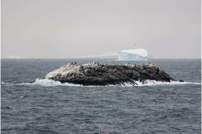
“I scoured all the coastlines we had here in the bathymetry lab and went back to the bridge. Looking out of the window, we saw an ‘iceberg’ that looked kind of dirty.” Dreutter explained. “On closer inspection, we realized that it was probably rock. We then changed course and headed in that direction and it became increasingly clear that we had an island in front of us.”
The team didn’t just rely on their eyes to map the structure. When they got close to it, they deployed the ship’s onboard multibeam echo sounder (a type of high-resolution 3D sonar) to scan the seabed, while a drone captured imagery later analyzed photogrammetrically to model the coastline and elevation.
The resulting data revealed a solid rock formation measuring 130 meters long and 50 meters wide, rising 16 meters above the freezing waves.
Melting Freshwater
The question now is where this island come from? Was it always there, disguised by heavy snow and ice, or did it recently emerge from the grip of a melting glacier?
Whatever the case, the Polarstern team suspects dramatic climate shifts in the region played an important role. Since 2017, the summer sea ice across the northwestern Weddell Sea has declined sharply, driven by warmer surface waters. The researchers have documented heavy surface melting, transforming the typically frozen landscape into something resembling the milder Arctic.
“The ice thickness showed great regional variability,” Prof. Dr. Christian Haas, head of the Polarstern expedition and AWI Sea Ice Physics, commented. “On the western, shallow continental shelf in particular, the ice was up to four meters thick, which we can attribute to strong deformation caused by the tides and the proximity to the coast. The ice further east came from the large Ronne and Filchner ice shelves and was less deformed with thicknesses of around one and a half meters.”
This widespread melting fundamentally alters the delicate polar ecosystem. As the ice degrades, it releases freshwater into the salty ocean below.
“Although we only found very few melt ponds, the ice was often almost free of snow and had a bluish or grayish surface,” Haas continued. “Thanks to novel measurements of the water directly under the ice using turbulence and biological probes, we found larger quantities of sweet meltwater in and under the ice.”
The Nameless Rock
For now, the rock remains nameless. As you might expect, getting a new island officially on the map is a slow and bureaucratic process.
The newly plotted coordinates will soon enter the International Bathymetric Chart of the Southern Ocean (IBCSO). Without precise measurements, poorly documented objects are often simply erased by interpolation algorithms. Now, the island is securely anchored in the data.
An international committee will review the discovery, a process that can take up to several months. By maritime tradition, the discoverers earn the privilege of suggesting a name. Dr. Boris Dorschel-Herr, the head of AWI bathymetry aboard the Polarstern, successfully named two underwater mountains back in 2014, and the crew is likely already brainstorming monikers for their accidental prize.
Until the ink dries on the official charts, it stands as a monument in the Weddell Sea—a reminder that even in the age of satellites, the Earth still holds a few surprises hidden under the ice.
This story originally appeared on ZME Science. Want to get smarter every day? Subscribe to our newsletter and stay ahead with the latest science news.