After record drought has gripped the Southeast, fueling fast-moving wildfires in Georgia and Florida, forecasters say some relief may be in sight from rain set to fall later in the week, while more changes to the weather are coming nationwide to close out April.
The wildfires burning tens of thousands of acres in the South have destroyed homes, prompted evacuations and closed major roads. Dry conditions and wind have made conditions prime for fire spread; over the weekend, one of the major fires burning in Georgia doubled in size, authorities said.
There are multiple rounds of rain and thunderstorms in the forecast for this week, AccuWeather reported. Though the rainfall will help fire efforts in the short term, it's not enough to reverse the record drought ongoing in the region, the outlet reported.
Start the day smarter. Get all the news you need in your inbox each morning.
"A more widespread soaking rain is expected from Texas to Georgia and northern Florida by late week, offering the best chance for meaningful relief and a temporary drop in wildfire risk," said Brandon Buckingham, AccuWeather meteorologist.
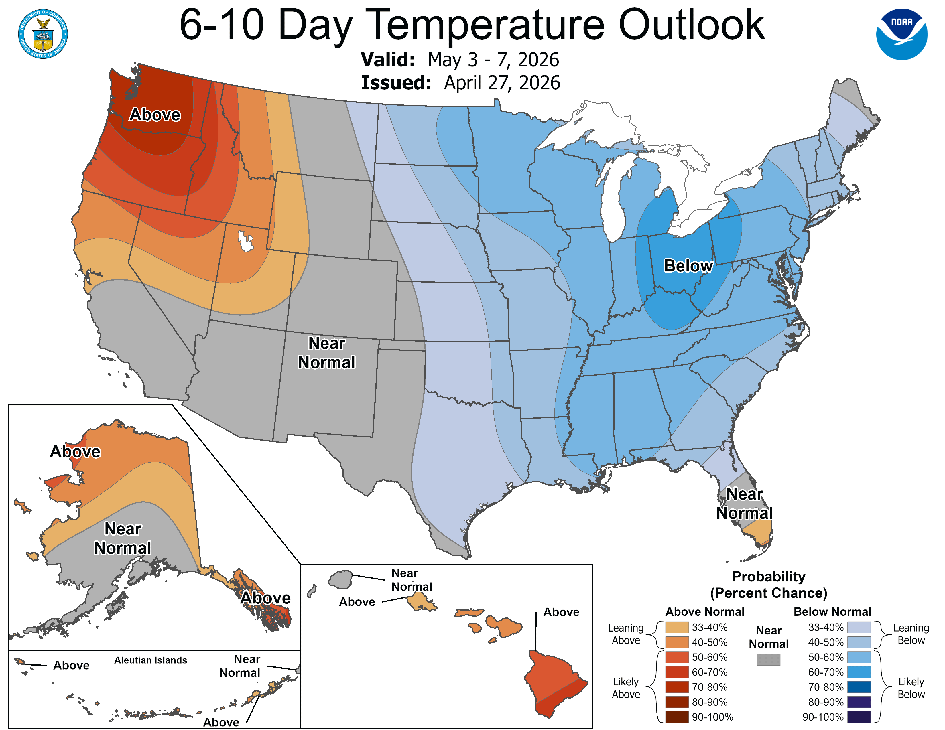
The moisture coming to the Southeast is one of several patterns of changing weather expected to sweep the nation over the coming week, including a cool spell in the East and calmer weather in the central United States, after a week of storms and tornadoes.
Hope for wildfire efforts as rain returns to forecast
Some areas in the Southeast could see an inch or more of rain by late week, while others may see none, AccuWeather reported. In any case, it won't be enough to spell long-term drought relief. It could help in the short term, however.
"This rain will help, but it’s not a drought-buster," Buckingham said. "It would take 10 to 20 inches or more of sustained rainfall to fully recover from the current drought."
Thunderstorms are expected along the Gulf Coast by midweek, bringing risks for damaging winds, hail and downpours. Then, widespread soaking rain is expected from Texas through Georgia and northern Florida on April 30 into May 1, AccuWeather reported.
The rain can help reduce the amount of dry brush and vegetation available to fuel the fire, which could last days or even up to a few weeks, Buckingham said. But the fire threat will ramp up again as everything dries out.
Cooler weather sweeps much of the country
A cold front is on its way east and will drop temperatures to 10 to 15 degrees below normal for this time of year in the Eastern U.S. starting April 30, the National Weather Service predicted.
As we head into May, a cold weather pattern will sweep the northern part of the country, the Weather Prediction Center said.
A cold high-pressure system coming from Canada will bring a chance of frost and freeze to the Great Lakes, Ohio Valley and Appalachians regions, forecasters said.
On Saturday, May 2, low temperatures will dip into the 30s and even high 20s in states including Minnesota, Wisconsin, Michigan, interior western New York and several other northern states in a spring freeze, forecasters said. The first weekend of May, there is also a chance of late-season snow in the mountains of northern New England and the Adirondacks, AccuWeather reported. From May 3 to May 7, below-normal temperatures are expected much of the eastern half of the country.
End in sight for back-to-back days of tornadoes, severe storms
The Central U.S. has seen back-to-back severe thunderstorms and tornadoes for the better part of a week, but forecasters say activity should begin to die down later in the week. There have been hundreds of reports of damaging wind and hail already this week, and over 30 tornadoes were reported over the weekend, AccuWeather reported.
Additional rounds of storms are expected on April 28, with the highest threat from northeastern Texas through Arkansas and into northern Mississippi, AccuWeather reported. Large to "giant" hail and a few tornadoes are a risk in the region, the Storm Prediction Center said.
On April 29, risk of storms shifts southward toward the Gulf Coast, but the "overall coverage and intensity of these storms is expected to be lower," the weather service said. By April 30, the Storm Prediction Center said the risk for severe storms is lower than 5%.
This article originally appeared on USA TODAY: Late April weather forecast calls for a big shift