Severe weather is again in play this first full week of May in the South, including cities such as Dallas, Austin and Houston through Wednesday. Wednesday's threat has increased to a level 3 of 5.
These areas were just some of the areas that got hit at the end of April, continuing the trend of the central U.S. seeing active severe weather since March.
(RECAP: End Of April Severe Weather Outbreak)
Happening Now
Storms are expected to fire up from Texas to Tennessee through the overnight hours. Some of these storms could impact cities like Dallas, Little Rock and Memphis. Rainfall will shift into the Ohio and Tennessee River Valleys, eventually moving into the mid-Atlantic and interior Northeast.
The Forecast
Tuesday Overnight/Early Wednesday Morning
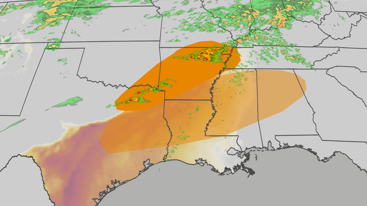
Northeast Texas, southeast Oklahoma and much of Arkansas into western Tennessee are in the bull's-eye for the strongest storms. That includes cities like Dallas, Little Rock and Memphis. Those along Interstate 40 and Interstate 44 need to be careful.
The main threats could be large hail (possibly over golf ball size), damaging wind gusts and a few tornadoes (some could be EF2 or greater).
There is also a low end threat of severe across the interior Northeast that will continue through the overnight hours.
Wednesday
The threat of severe storms has increased for Wednesday, now a level 3 of 5.
We expect clusters of severe thunderstorms over parts of the South from the Tennessee Valley to the lower Mississippi Valley and eastern Texas from the afternoon into the evening hours. That includes cities such as Birmingham, Jackson and Shreveport.
Damaging wind gusts and hail, possibly larger than golf balls, are possible in these storms. Some tornadoes are also possible, especially if discrete supercell thunderstorms are able to form in the lower Mississippi Valley (northern Louisiana, southern Arkansas into Mississippi). There is even a chance of EF2 or greater tornadoes.
Again, this severe threat is expected to last well into the evening in the Deep South.
Heavy Rainfall, Too
These storms will also wring out some locally heavy rainfall over parts of the South, much of which is experiencing some sort of drought. Flood watches are issued for northern Georgia and will likely be expanded in the coming hours.
Widespread 1-3 inches of rainfall is expected, a good amount for soils to be able to handle the absorption process. We need more days like this to continue to chip away at the longstanding drought.
However, we can't rule out local flash flooding in a few spots, where heavy rain falls too quickly, as we saw last week in places like Baton Rouge, Louisiana.
The Setup
There are a couple of factors that are all coming together for this severe weather. We have a subtropical jet that is traveling across the southern U.S. This jet will help enhance moisture across the South.
There will also be a southward plunge of the northern jet stream, known as a trough, coming over the Rockies. The conditions will be favorable for a low-pressure system to form between these upper winds.
That trough will bring in unseasonably cool air while the subtropical jet will enhance the warm, moist air over the South. The clash of these air masses is a classic setup for May, the busiest month for tornadoes on average.
(MORE: What May Brings In Terms Of Weather)
Rob Shackelford is a meteorologist and climate scientist at weather.com. He received his undergraduate and master’s degrees from the University of Georgia studying meteorology and experimenting with alternative hurricane forecasting tools.