Severe weather is targeting parts of the South through Wednesday, the final day in a six-day rash of thunderstorms packing hail, high winds and tornadoes since last Thursday from the Plains and Midwest into parts of the South.
(MORE: Severe Weather Safety Tips)
Happening Now
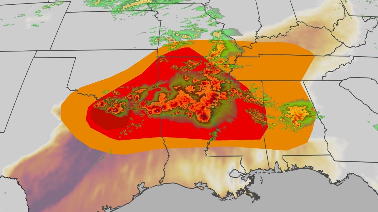
Widespread severe thunderstorms are ongoing from Texas to the Deep South with the threats of very large hail, damaging winds and a few tornadoes. Hail could be as large as baseballs in a few spots, especially in Texas.
A tornado has caused damage near Mineral Wells, Texas.
The map below shows a radar of the current situation, including current watches and warnings.
Wednesday: Storms For Houston, Charlotte and Washington D.C.
The severe threat is expected to be much lower on Wednesday, however, there's still a chance for storms across portions of the Deep South and mid-Atlantic.
As the front finally clears the Southeast, these storms will eventually push offshore.
Siege Recap
Since last Thursday, there have been almost 900 reports of severe thunderstorm winds, wind damage, hail or tornadoes in the U.S. in the latest spring siege of severe weather.
Thursday brought almost two dozen tornado reports from Oklahoma to Iowa, as well as over 160 damaging wind and hail reports combined.
On Thursday evening, a rare tornado emergency was issued for the storm that tore through Enid, Oklahoma and the nearby Vance Air Force Base, warning of catastrophic damage and threat to life. The resulting tornado was rated EF4 with winds of 170-175 mph. It was the first EF4 in Garfield County, Oklahoma, since April 26, 1991. There were 10 injuries from this tornado.
There were five other tornadoes reported from the National Weather Service in Norman, Oklahoma.
The NWS office in Norman noted it was only the ninth time the office has issued a tornado emergency.
(MORE: Different Types Of Tornado Warnings)
There was also a gust of 107 mph at Vance Air Force Base, Oklahoma. The most impressive hail report was a report of 4 inches in diameter, or softball-sized hail, in Marion, Kansas.
As forecasted, Friday was less impactful. There was only one tornado report in Kiowa, Oklahoma, but there were 10 tornado reports in Mississippi. There was more than 120 damaging wind and large hail reports combined.
Saturday brought more intense storms, and roughly a dozen tornado reports, mainly across Texas and Oklahoma. In Alpine, Arkansas, there was a hail stone recovered that was between 4-5 inches in diameter. Other reports of hail the size of tennis balls and hen eggs and even some reaching the size of softballs across Kansas and Texas.
As storms continued through Texas early Sunday morning, two people were killed. One person in Wise County and another person in Parker County.
On Sunday, there were over 90 hail reports, over 50 damaging wind reports and seven tornado reports across the Plains. Some tornado warnings even had "particularly dangerous situation" tags indicating large and powerful tornadoes in progress. Notable ones were reported in Sycamore, Kansas, as well as near Joplin, Missouri. Joplin is no stranger to powerful tornadoes.
(MORE: Joplin EF5 Tornado In 2011)
A barn was destroyed and homes damaged in Edgerton, Kansas. Numerous downed trees and powerlines and flooded roads were reported in Missouri and Kansas, with numerous water rescues reported in the Kansas City metro.
For more on the severe weather on Sunday as it unfolded, click the link below.
(MORE: Live Updates | April 26)
Monday brought over 300 storm reports across the mid-Mississippi River Valley.
Only 3 tornado reports have been recorded so far, but there was an impressive 195 damaging wind reports and 122 large hail reports.
Of the three tornado reports, two of them occurred in Arkansas, while one tornado report was in Illinois.
In Piney Park, Missouri, hail the size of softballs, or 4 inches in diameter, were reported.
For more on the severe weather on Monday as it unfolded, click the link below.
(MORE: Live Updates | April 27)
Make sure you have multiple ways to receive alerts, should severe weather strike in your area.
Jennifer Gray is a weather and climate writer for weather.com. She has been covering some of the world's biggest weather and climate stories for the last two decades.