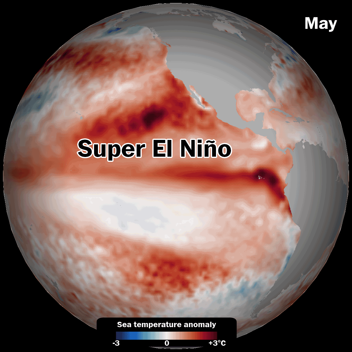
Chances are rising that an El Niño expected to form soon could become one of the most powerful such events on record, according to new data released this week.
The latest outlook from the European Center for Medium-Range Weather Forecasts (ECMWF) shows water temperatures in a key region of the central equatorial Pacific Ocean potentially reaching 3 degrees Celsius (5.4 degrees Fahrenheit) above average late in the year. That could approach or even surpass the current records set in 1877 and 2015 and exceed the threshold for a super El Niño.
“Confidence is clearly shifting higher on potentially the biggest El Niño event since the 1870s,” wrote Paul Roundy, a professor of atmospheric science at the State University of New York at Albany. Records for El Niño began around 1850.
It’s the third consecutive month that multiple models have predicted that a potentially record-breaking El Niño could drive global temperatures to new highs and shift patterns of droughts, floods, heat, humidity and sea ice across the planet. The coming conditions could have significant consequences for agriculture, health and the economy across the planet.
The odds for a powerful El Niño were boosted by a rare triplet cyclone pattern in the Pacific last month, which caused a record-breaking burst of wind that created a freight train of warm water beneath the ocean surface that’s reached 7 degrees Celsius (12.6 degrees Fahrenheit) above average. That’s a major anomaly in the ocean, which typically takes a long time to warm up and cool down.
“El Niño patterns are correlated with food shortages, water impacts and even civil conflict in tropical countries,” said climate scientist Katharine Hayhoe. “So these natural patterns of variability, as short-lived as they are, still have a profound impact on human society and human well-being.”
El Niño is gradually beginning to affect weather patterns, with NOAA data suggesting the phenomenon may fully form by July.
These are some of the weather impacts predicted to unfold through November that are at least partly connected to the developing El Niño:
The strongest El Niño events almost always cause a record-warm year. That’s because El Niño releases heat from the ocean into the atmosphere, and then global wind patterns and weather systems act like conveyor belts, moving that heat around the world.
And in 2026, there’s extra heat compared to the past.
This could contribute to milder winter temperatures in the U.S. — as well as big storms along the West Coast and the drought-stricken South — as El Niño’s impacts reach a peak from the end of the year into early 2027.
Climate scientist Zeke Hausfather wrote that 2026 is on track to become the planet’s second warmest year on record. The stronger El Niño becomes, the higher the chances will be for a record warm year, especially in 2027 — because air temperature increases lag slightly behind El Niño’s development and peak. There’s currently a 73 percent chance that 2027 will become the planet’s warmest year on record, according to Hausfather.
Meanwhile, worldwide interest in the super El Niño phenomenon appears to be at a high.
Since 2003, the term has been included in 149 research papers available on the American Meteorological Society website — a number that may rise as the effect of another potential super El Niño takes hold.
Brady Dennis contributed to this report.