Forecast totals for the Pikes Peak summit reach as much as 35 inches over three days, though the official Winter Storm Warning for the broader Rampart Range zone covers 8 to 16 inches.
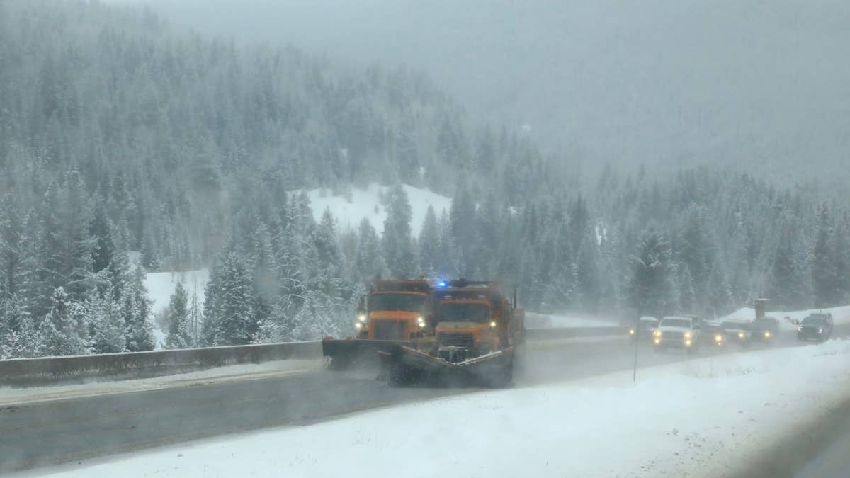
Late April normally means the snow tires come off. This week, southern Colorado and northern New Mexico get the opposite, and the timing is awkward in a specific way. The storm hits the higher elevations first, then the snow level drops to 7,500 feet by Friday morning behind a cold front. Roads that look wet at 6 p.m. Thursday could well be fresh ice by sunrise.
If you're crossing I-25 at Raton Pass, the I-70 ski corridor, or any of the southern Colorado mountain passes, avoid the overnight window Thursday into Friday — that's when conditions will be at their worst. Leave Thursday afternoon to get ahead of it, or hold off until Saturday. Everything else is secondary.
I-25 and Raton Pass
If you're driving I-25 between Trinidad and Raton tonight, the question isn't really whether the road gets bad, it's when. Raton Pass sits at 7,834 feet, and the snow level is forecast to drop to exactly that elevation by Friday morning. So the transition from rain into accumulating snow lands somewhere in the small hours, on the most important freight corridor between Denver and Albuquerque.
NWS Albuquerque has the warning running from 3 p.m. Thursday through midnight MDT Friday. 2 to 8 inches between 7,500 and 9,500 feet, 8 to 14 inches above. They're explicit about chains being likely necessary, which is unusual for late-April language out of that office and is worth taking seriously. The same alert covers the Sangre de Cristos on the New Mexico side and the Johnson and Bartlett Mesas, so US-64 east of Taos is in the same forecast.
I-70 Mountain Corridor: Eisenhower Tunnel, Berthoud Pass, and the Ski Areas
This is closing weekend at Arapahoe Basin, so whatever else is happening with the storm, that's the context for the I-70 traffic this week. Full lots, full lifts, and a lot of vehicles moving west out of Denver who have already committed to the trip.
NWS Boulder has the entire mountain corridor under Winter Weather Advisory through 6 a.m. Friday, with 5 to 13 inches expected and the heaviest amounts in the Front Range Mountains south of I-70 and the Mosquito Range. Eisenhower Tunnel at 11,158 feet is the usual choke point and will be again. Berthoud Pass on US-40, the alternate route to Winter Park, runs higher and gets there first.
Rocky Mountain National Park is fully inside the advisory zone, which is its own headline given the spring opening calendar. The named locations in the bulletin read like a Colorado ski-area itinerary. Breckenridge, Winter Park, Fairplay, South Park, Cameron Pass, Willow Creek Pass, Lake George, Mount Blue Sky, the Indian Peaks, the Medicine Bow Range, the East Slopes of the Southern Gore Range. NWS Boulder calls out the Thursday evening commute specifically. That's the window where the conditions and the volume of traffic collide.
The picture extends further south through NWS Grand Junction, which has Winter Storm Warnings across the San Juans (Telluride, Pagosa Springs, Wolf Creek Pass) and advisories around Aspen and Vail Pass.
Sangre de Cristo and the Wet Mountains
La Veta Pass on US-160 is the only sensible way from I-25 at Walsenburg into Alamosa and the San Luis Valley if you don't want to go all the way up through Salida. Poncha Pass on US-285 is the alternative, and it isn't much better. Both are inside the NWS Pueblo Winter Storm Warning that covers the Sangre de Cristos and Wet Mountains through midnight MDT Friday. 8 to 16 inches across the range, concentrated on the east-facing slopes. Cuchara, Spanish Peaks, Blanca Peak, and Stonewall round out the included passes.
Down in Westcliffe and Silver Cliff, the Wet Mountain Valley itself sits below 8,500 feet and runs a separate advisory through Friday noon for 3 to 7 inches, with more on the eastern side as you climb back toward the higher terrain. Whether the forecast verifies on the higher end is another question. The Pueblo office tends to verge cautious, which makes this one worth taking seriously.
Pikes Peak and Colorado Springs
The official Winter Storm Warning for Teller County and the Rampart Range matches the Sangre de Cristos at 8 to 16 inches, holding until noon MDT Friday. Point forecasts for the summit of Pikes Peak itself, above 14,000 feet, run as high as 35 inches over three days. That's a peak-elevation projection, not a warning-zone average, but it's where the "three feet of snow" headlines elsewhere are coming from. Take it for what it's worth.
For drivers, the relevant stretch is US-24 between Colorado Springs and Woodland Park, plus the climbs out of Manitou Springs. There's a brief lull early Thursday before intensity builds again through the day.
Front Range Foothills, Boulder, Denver
The Boulder advisory zone reaches well east of the high peaks. The Front Range Foothills from Fort Collins down through Boulder and Castle Rock all sit on the edge of the advisory, with Denver metro itself right at the boundary. The Thursday evening commute is the affected window, and anyone heading west out of Denver toward the ski areas climbs straight into the worst of it within thirty minutes.
Mosquito Range and CO-91
A Pueblo advisory covers the Western Mosquito Range and the higher elevations of Lake, Chaffee, and Fremont counties, including Climax. CO-91 over Fremont Pass, between Copper Mountain and Leadville, sits in the middle of it. 5 to 10 inches through Friday noon. If your trip splits between the I-70 ski corridor and the Buena Vista or Leadville side, that's mountain-pass conditions on both ends.
What's Not in This Storm
The northern edge stays out of southern Wyoming. NWS Cheyenne has nothing more than a Special Weather Statement around Medicine Bow, so I-25 north of the state line and I-80 across southern Wyoming are clear. South of Raton, the same low-pressure system is producing rain rather than snow across the Texas and Oklahoma panhandles. NWS Amarillo is calling for half an inch or more around Amarillo and Hereford. Useful context for I-40, but not a winter-driving story. Freeze Warnings in parts of Utah and southeastern Idaho cover overnight cold, not snow on the roads.
Before You Drive
Pikes Peak and the I-70 corridor advisories lift Friday morning. Sangre de Cristo and Raton warnings hold through midnight Friday night. By Saturday this is mostly gone.
Call 511 in whichever state you're driving. For Colorado, use cotrip.org, for New Mexico nmroads.com - both faster than anything else for road conditions. Chains belong in the vehicle if you're crossing Raton, La Veta, Poncha, Wolf Creek, Eisenhower, Berthoud, or Vail tonight.
The snow-level drop is what catches people. Wet pavement at 7,500 feet on Thursday evening is ice by Friday morning, and the bridges and overpasses on the lower-elevation approaches get there first. Why both interstates are taking the same hit on the same night, the storm doesn't care to explain. Friday afternoon most of this clears. The overnight window is the part that takes some thought.